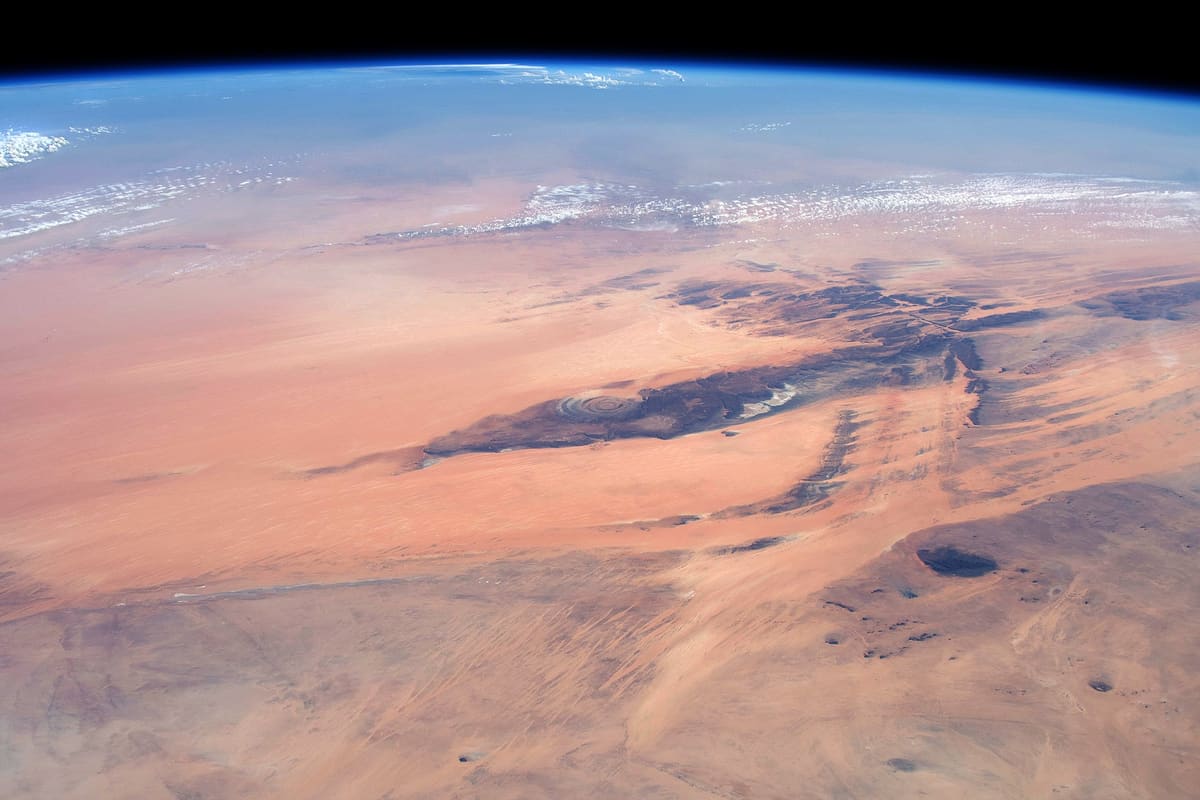
 NASA / Wikimedia Commons, Public domain
- Established Peer-reviewed or mainstream consensus: the claim is as settled as archaeology gets.
- Suggestive Plausible and evidence-backed, but limited, evolving, or not yet mainstream.
- Contested Disputed among researchers, or popular-press overreach of what the evidence actually shows.
In the Sahara of Mauritania, on the Adrar Plateau, the desert opens into an enormous bullseye: concentric rings of rock some forty kilometres across, so large and so geometrically regular that astronauts have used it as a navigational landmark from orbit since the 1960s. It is called the Richat Structure, or the Eye of the Sahara, and from above it looks unmistakably designed. The geology says otherwise. The human pattern-seeking brain does not always agree.
What the geology actually shows
For years the Richat Structure was assumed to be a meteor impact crater. The hypothesis was reasonable: the circular form, the scale, the exposed rock layers. It is not a crater. Established
The peer-reviewed geology, established by Matton and Jébrak in 2014, identifies it as an eroded alkaline-intrusion dome: magma pushed up from below during the mid-Cretaceous period, roughly 99 to 100 million years ago, creating a dome of uplifted rock that has since been worn down by tens of millions of years of erosion. Harder and softer rock bands erode at different rates, which is why the rings are so distinct. The structure is also designated a Geoheritage Site by the International Union of Geological Sciences. Established
Matton & Jébrak (2014), "The ‘eye of Africa’ (Richat dome, Mauritania): An alkaline complex grown during Gondwana breakup," Journal of African Earth Sciences 97: 109–124 – ScienceDirect; IUGS Geoheritage designation – iugs-geoheritage.org; NASA Earth Observatory – nasa.gov.
The impact hypothesis was rejected partly because no shocked quartz was found. An earlier claim of coesite, a high-pressure mineral that would indicate an impact, turned out to be a misidentification of barite. ESA has also published satellite imagery confirming the scale and structure from orbit. Established
ESA "Earth from Space: Eye of the Sahara" (2025) – esa.int.
The Atlantis question: what the internet says and what archaeologists say
Because the Richat Structure is a series of concentric rings of rock, and because the region around it was significantly wetter during the period when modern humans first populated it, it has attracted an Atlantis hypothesis. Plato described Atlantis as a city of concentric rings of land and water. The Sahara really was green within the span of modern human history. The shape roughly fits. The size very roughly fits. Contested
The mainstream archaeological response is firmly sceptical. The Richat Structure sits deep inland, far from the ocean that Plato said swallowed Atlantis. There is no archaeological evidence of the kind of advanced civilisation Plato described anywhere near the site. Archaeologist Sean M. Rafferty has characterised the Atlantis-Richat claim as an “unsubstantiated fringe” proposal; the hypothesis was popularised not by academic researchers but by YouTube content creators, most notably the “Bright Insight” channel. Contested
The appeal of the idea is real, even knowing all of this. A structure so vast and so ring-perfect, in a desert that was once fertile land, produces a kind of cognitive vertigo that the geology alone cannot fully dissolve. The rings are exactly what erosion of an alkaline dome produces. They also look exactly like what you would build if you were Plato’s engineers and had a continent to work with.
What remains genuinely open
The geological story is settled. The Atlantis identification has no academic support. What the landscape looked like during the Green Sahara period, roughly 11,000 to 5,000 years ago, and who if anyone lived near the structure at that time, is a matter of ongoing palaeoclimatological research rather than settled archaeology. Suggestive The structure itself is not inhabited or excavated. It is simply there, forty kilometres of ancient ring-perfect rock in the middle of one of the most inhospitable places on Earth.
Where the real places end and the story begins
The rings, the scale, the geology, the Atlantis debate: all real, all visible on any satellite map. You can see the Eye of the Sahara from space with your own eyes using freely available imagery.
The novel reaches the Richat last among these western sites, and the place earns its position: it is the one location on the trail where the geology itself seems to be making an argument, where the pattern is so insistent and so large that even knowing exactly how it formed does not entirely settle the feeling that you are looking at something that should not be there. The fiction takes that feeling seriously. What the characters find there belongs to the story, not to the record.
One more site on the trail
Get the complete Real Places field notes as a PDF now, plus each new site as it drops
All eight sites in one PDF, including Rosslyn Chapel, the last stop on the trail. Yours the moment you join, then each new place as the series continues.
Never shared. Leave any time.Next site on the trail
Rosslyn Chapel
55.8554° N, 3.1598° W · Midlothian, Scotland
Stolen Genesis: Legacy Denied is Book One of the Stolen Genesis series. The locations are real.